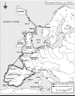
Путешествие Пифея
 andy4675
08.04 2014
andy4675
08.04 2014
Exploration in the
World of the Ancients
JOHN S. BOWMAN
JOHN S. BOWMAN and MAURICE ISSERMAN
General Editors
Pytheas Voyages North
About 315 B.C., Pytheas, a citizen of
the Greek colony of Massalia, on the
Mediterranean coast of France, headed
his ship westward to the Pillars of Hercules.
This was the ancient Greeks’ name for
the Strait of Gibraltar, the body of water
between Gibraltar and North Africa. (A Greek
myth claimed that Hercules had placed two
rocks to guard the strait.) To pass through
this strait at that period of history was a
major undertaking by a ship captain: It
meant heading for the uncharted waters
and unknown lands of the North Atlantic
region. But Pytheas had set his sights on just
such a voyage.
Even before he reached the Pillars of Hercules,
Pytheas faced potential dangers. Massalia
had been founded about 600 B.C. by
Greeks from the city of Phocea on the coast of
Asia Minor (modern Foca, in Turkey) and in
the centuries since had grown and prospered
as a center of Greek culture and commerce in
the western Mediterranean. Located just east
of the mouth of the Rhone River, Massalia
served as an entrepôt, or trading center, for
merchants from all over the Mediterranean
and merchants who came down the Rhone
from northwestern Europe.
During those same centuries, another city
on the opposite shore of the Mediterranean
had also grown powerful and prosperous. This
was Carthage, on the coast of North Africa
(modern Tunisia) almost due south of Massalia.
Carthage had been founded about 750
B.C. by Phoenicians from the eastern coast of
the Mediterranean—modern Lebanon. The
Carthaginians were an assertive people, determined
to dominate the maritime traffic and
commerce in the western Mediterranean.
(Within 50 years the Carthaginians would be
fighting Rome for mastery of the western
Mediterranean.) Carthaginians had established
their own colonies along the coast of Spain,
and they did not take kindly to the Greeks who
also wanted a share of the commerce.
In particular, their colony of Gades (modern
Cadiz), on the coast of Spain just outside
the Pillars of Hercules, was positioned to cut
off Greeks or others who might seek to sail out
of the Mediterranean. Pytheas made his way
along the south coast of France, down the east
coast of Spain, through the Pillars of Hercules,
and then along the southern coast of Spain
and Portugal. He must have been very clever
or lucky to avoid any conflict with Carthaginians
because ships in those days sailed and
rowed quite close to the coast during the day.
Pytheas’s ship, by the way, was most likely
a merchant, or cargo, ship, not a warship.
Those were the two major types of ships at
this time. Warships were designed for speed
and strength and were relatively shallow, long,
and trim; they were propelled by many oarsmen.
This type of ship would not have been
practical for a long voyage. Merchant ships
were designed to hold cargo and so were
deeper, broader, and sturdy; most were propelled
by one large sail attached to a central
mast, but some merchant ships also had several
oarsmen on each side. Both warships and
merchant ships were steered mainly by large
oars at the stern, or the rear, of the ships.
For a journey as ambitious as that of Pytheas,
his ship probably had oarsmen—perhaps
10 on each side. His total crew may have been
about 30 men. The oarsmen enabled the ship
to make some progress during the hours when
there was no favorable wind. Even so, the ship
probably only averaged about five or six miles
an hour, so that on a long day they might
cover some 50 miles. The energy expended on
keeping such a ship moving must have
required a fair amount of calories and liquids
for the crew, so they had to pull their ship
ashore each night to replenish their food and
water supplies.
THE JOURNEY
Once past the southwestern corner of the
Iberian Peninsula, Pytheas sailed northward
along the Atlantic coast of Portugal and northwestern
Spain. Arriving at the Bay of Biscay, he
almost certainly stayed fairly close to the coast
of France until he arrived at the great promontory
of Brittany. Proceeding along it, he
reached the island of Ushant, the westernmost
territory of modern France. At that point
he had to make one of his longest “runs” in the
open sea—some 100 miles, a solid 24-hour
trip, to reach the southwestern coast of England.
Once there he proceeded to the region
known to him as Belerion, today known as
Land’s End, the promontory of Cornwall, England’s
southwesternmost region.
Pytheas may not have been the first
Mediterranean mariner to have sailed this
route, although he would be the first to provide
a written report of many of the features
of the coast. (The book he wrote has never
been found, but during the following centuries
many ancient writers quoted from it.)
When Pytheas reached England, his voyage
becomes a major contribution to the history
of exploration. The people of the Mediterranean
had only the vaguest notion of the
lands in northwestern Europe, especially the
islands later to be known as the British Isles.
What they did know, though, is that a particular
material came from somewhere in that
region: tin.
Tin was among the scarcest and most valued
products sought by the peoples of the
Mediterranean. For some 3,000 years, they
had been mixing tin with copper to form a
durable alloy, bronze. Bronze was used for
making everything from weapons to religious
objects, from armor to jewelry, from tools
to coins, from statues to drinking vessels.
Copper was relatively plentiful around the
Mediterranean, but tin was obtainable from
only a few sources. For some centuries, tin
had been imported into the Mediterranean
region from northwestern Spain and the
British Isles. After being extracted from its
rocky ore, the metal was transported overland
through Spain or France to the shores of the
Mediterranean.
Massalia was one of the major trading centers
for tin, but most of the Mediterraneans
involved in this trade had little knowledge of its
places of origin. They were dependent on the
middlemen who transferred it from its source,
and this added considerably to the price. There
were rumors of rich tin mines on islands in that
northern ocean; indeed, the Greeks’ word for
“tin,” kassiteros, had been given to the distant
islands believed to be the source of tin, the
Cassiterides. Evidently some of the merchants
of Massalia wanted to make direct contact with
those miners, and that seems to have been one
of the chief goals of Pytheas’s expedition—
to find those tin mines. When Pytheas arrived
at the islands off Cornwall, he was convinced
he had found that place.
In fact, he soon discovered that the tin
mines were on the mainland of Cornwall, and
Pytheas would describe the process:
They extract the tin from its bed by a cunning
process. The bed is of rock, but contains
earthy interstices, along which they
cut a gallery. Having melted the tin and
refined it, they hammer it into knucklebone
shape and convey it to an adjacent island
named Ictis [possibly St. Michael’s Mount
off the coast of Cornwall].
Having satisfied himself that he had found
the source of the tin—and possibly loaded his
boat with some—Pytheas then sailed completely
around Great Britain. His reported
measurement of the coastline—based on estimates
of the length of land passed in his daily
voyage—was surprisingly exact, and he got one
thing right: “Britain is triangular like Sicily, with
three unequal sides.” And he did more than sail
along the coast; although most scholars cannot
accept his claim that “I traversed the whole of
Britannike accessible by foot,” he does seem to
have made occasional visits into the interior,
and he reported on the people he encountered:
The inhabitants of Britain are said to have
sprung from the soil and to preserve a primitive
style of life. They make use of chariots
in war, such as the ancient Greek heroes are
reputed to have employed in the Trojan
War; and their habitations are rough-and-
ready, being for the most part constructed
of wattles or logs. . . . They are simple in
their habits and far removed from the cunning
and knavishness of modern man.
When he reached the northern coast of
Scotland, he was told about the island of
Thule, which he claimed was six days’ sail
north of Britain. He did not venture that far,
but he did report that around Thule “there is
neither sea nor air but a mixture like sea-lung,
in which earth and air are suspended.” Exactly
what he meant by “sea-lung” would never be
known for sure; some say he was describing
jellyfish, some say slush-ice, but very likely he
was describing the thick, clammy fogs of
the North Atlantic. He also described large
fish blowing out sprays of water—obviously
whales. As for Thule itself, some claim it is Iceland,
others Norway, still others the Shetland
Islands. In any case, he also reported that
Thule was so far north that, in the middle of
summer, the sun went down for only two or
three hours. In general, much of what Pytheas
would describe and report was a mixture of
the truth and misunderstanding.
After completing his encirclement of
Britain, Pytheas returned across the Channel
to the coast of France or Belgium, then sailed
north along the coasts of the Netherlands and
Germany. Exactly how far northeastward he
sailed is not known, for the names he assigned
to the geographic features he saw cannot be
attached with any certainty to known features
today. But it does appear he moved into the
North Sea, possibly as far as the mouth of the
Elbe River, where he probably turned back
when he confronted the great peninsula
topped by Denmark.
In any case, he retraced his voyage home
by sticking close to the coast of western
Europe and appears to have arrived safely
home in Massalia. His journey had covered
some 7,500 miles, longer than Christopher
Columbus’s roundtrips to the New World. But
unlike Columbus’s voyage, what happened as
a result of Pytheas’s voyage is unknown. There
is no evidence of much of anything changing
in the tin trade, for instance. As for Pytheas, he
vanishes from history. Even the book or report
he wrote about his voyage did not survive in
its original copy.
THE SIGNIFICANCE
OF PYTHEAS
Nothing is known about Pytheas before or
after his voyage. He is known only from allusions
to him and quotations attributed to him
by several ancient Greek and Roman writers—
primarily Diodorus Siculus (fl. 60–20 B.C.),
Strabo (ca. 63 B.C.–A.D. ca. 24), and Pliny the
Elder (A.D. 23–79). Ironically, several of the
ancients who describe Pytheas regarded him
as a liar—that is, they did not believe he had
made the voyage or discovered the things he
described. Although some of these ancient
writers quote long passages from the report
written by Pytheas—it is these secondhand
quotations that have been cited here—no part
of the original has survived. This in itself is not
that unusual: There are many famous individ-
uals from the ancient world about whom
nothing is known except from references in
various texts. But there are enough consistent
references to Pytheas that modern scholars
are convinced such a man did exist. All who
wrote about Pytheas located him in Massalia,
and they seem to place his voyage sometime
between 325 and 305 B.C. His name suggests
he was a Greek, and he was almost certainly of
Greek descent, but considering that the
Greeks had been settled in Massalia since
about 600 B.C., and that various other peoples
lived in the immediate environs, he may well
have been of mixed heritage.
If so little is known of the man, why do all
who write about the beginnings of exploration
in the ancient world devote so many words to
Pytheas? Why does he stand as an archetypal
figure of the explorer?
Some of the ancient texts suggest that
Pytheas was a relatively poor man, that he
was of no great distinction, but simply undertook
the voyage as a commercial venture.
It then has been suggested that he must
have had the backing of wealthier merchants
in Massalia who wanted Pytheas to locate
the exact sources of tin so they could purchase
this directly and so outmaneuver the
Carthaginians in their attempt to monopolize
the tin trade. Not only that, the Massalians
might then eliminate the middlemen involved
in the overland route down across France.
In any case, it seems almost certain that
Pytheas must have been at least partially
motivated by the prospects of profit. If not a
prosperous merchant himself, he must have
appreciated what lay in store for him should
he complete such a voyage. At the same time,
it is highly unlikely that a poor man could ever
have been able to finance the ship and crew
necessary for such an expedition. So if he was
relatively poor, he must have had enough of a
reputation that the merchants of Massalia
supported him.
Whoever he was, whatever motivated him
to undertake such a voyage, he must have
been a master mariner. Sailing a ship for thousands
of miles in those days was no easy
feat—most ships never sailed that far from
their home ports. Although the Mediterranean
Sea extended some 2,200 miles from
the eastern shores to the Pillars of Hercules
and 600 miles at its widest, most ships at this
time would never have considered trying to
sail to such distant shores. They loaded and
unloaded their cargoes at various intermediate
ports. In any case, they put into familiar
and safe harbors at night. They never ventured
that far from coasts, and they knew the
various landmarks. When navigational skills
were called for, they knew the winds, they
knew the stars, they knew the dangers lurking
beneath the waves. But Pytheas sailed into
completely unknown, uncharted seas. There
were no maps or charts, no familiar landmarks,
no way to know about the reefs or
rocks as he approached a shore. He had to be
a master mariner, a master navigator.
Some of those who wrote about him, in
addition to referring to him as a master
mariner, treated him as a serious astronomer.
They credited him with asserting—rightfully—
that there was no star precisely over the
North Pole. At least one ancient text that
referred to him said that he set off on his voyage
to confirm this claim. He was one of the
first known people to have connected the
influence of the moon to the rise and fall of
the tides. Also, by carefully calculating the
changing position of the sun and the resultant
length of shadows, he was able to calculate the
latitude of Massalia quite accurately. On his
voyage, he also recorded the lengthening of
the days as they proceeded northward, and by
observing the height of the Sun, he calculated
the latitude at various points along the way.
Many geographers and mapmakers who followed
Pytheas used his latitude for Massalia
as the basis for calculating the latitudes of
other points in the known world.
There was another skill that Pytheas must
have had. It was not enough to guide a ship
safely through hundreds of miles of ocean.
The ship had a crew—exactly how many is not
known, but most likely about 30, including
oarsmen, sail crew, and officers. These men
had to be provided with adequate food and
drink, day after day. They put into shore every
night and probably often stayed several days
while they replenished their food supplies—
sending out hunting parties and water seekers.
Men probably got sick or injured. His ship
must have occasionally required repairs.
Often he had to deal with the native inhabitants.
He probably carried some valuable
cargo that he could use as barter, that is, to
trade for vital supplies. So Pytheas had to be a
good administrator of such an expedition.
This meant not just satisfying material needs.
He must have been a good leader of men,
someone who could inspire his crew to keep
going, to persevere against all odds.
In recent times, some speak of Pytheas as
though he was a lone adventurer, setting out
to explore for the sake of exploration, for the
sheer sake of revealing the unknown, of finding
what lay back of beyond. That is probably
too modern a notion of such a man and such
an expedition. But there had to be something
of the adventurer in Pytheas. No one could
have forced him to undertake such a voyage.
Meanwhile, there must have been hundreds,
even thousands of mariners in Massalia who
did not choose to go. He had to have some
special spark, some special vision. And he certainly
had to have courage—the willingness to
set forth into the unknown, the guts to face all
that nature and humans might throw at him.
Physical strength, too: Although there might
have been an element of good luck for men of
his era to survive and endure, Pytheas must
have overcome hardships of many kinds:
storms at sea, cold and wetness, lack of proper
foods, and occasional accidents and injuries.
It turns out, then, that Pytheas must have
combined in himself many of the main elements
that will be found in explorers not only
in the ancient world but also in explorers
across the ages and of all cultures. Not all
explorers had all these qualities and characteristics
and skills, but they had to have some
of them. Some would be driven primarily by
the profit motive, often expressed as a desire
to seek gold. But even if they had that personal
goal, many like Pytheas needed to gain the
support of others, whether fellow seekers after
personal profit or rulers who wanted the profits
for their realms. Like Pytheas, almost all
explorers had to have the knowledge and skills
either to navigate ships or conduct expeditions
across unknown terrain. They had to be
able to organize the logistics of an expedition—
provide the food and shelter needed,
maintain the ships or the animals. They had to
be able to inspire their “teams,” to hold the
members of their expeditions together
through thick and thin. Some explorers, it is
true, were motivated by an almost pure desire
for understanding the world—advancing the
sciences, adding to knowledge, enlarging the
known. But all must have had some sense of
adventure. Even the most scientific of explorers
had to have something that took them out
of the library or the laboratory to set forth and
confront unknown physical challenges. So all
had to have some form of courage. Possibly,
too, they had a touch of ego to think that they
could carry off what lesser men might not be
up to undertaking.
Finally, what links Pytheas to many of the
great explorers who followed, but distinguishes
him from most who went before him,
is that he does seem to have written an
account of his voyage. He was wrong about
many of the details he described. He was not
believed by many of his contemporaries. But
the point was that he brought these dim and
distant lands into the light of human awareness.
It was not enough to travel bravely to
distant lands. Unless some record was made,
some report, even contemporaries would not
know for certain what lay out there, and posterity
would definitely not know. There have
been explorers who have personally shown little
or no interest in recording their discoveries
or their own role in daring expeditions. But
one way or another, someone must set down
an account for the world to profit, to add to its
steadily enlarging realm of the known.
Most explorers before Pytheas did not
record their adventures, but this does not
mean that the world had not been explored.
Clearly there were people living all over the
earth by the time Pytheas made his voyage of
“discovery.” Before giving credit to the many
brave explorers known to have preceded and
followed Pytheas, it seems necessary to recognize
the many anonymous and unsung people
who were truly the first to open up the
world.
Ancient Navigation =
In the thousands of years before Pytheas that humans had been sailing the
open seas, and for at least another 1,500 years, the knowledge, skills, and
devices used for navigating ships hardly changed. Most mariners basically
depended on dead reckoning—estimates of their location at sea based on
some sense of a distance traveled and the time elapsed, modified by such matters
as position of the sun and the strength of the winds. Furthermore, they
depended on a store of common knowledge (e.g., familiar landmarks, the rising
and setting of the sun, and the positions of certain stars and planets).
In the Mediterranean, except for coastal trips, most ship traffic ceased by
about November 1 and did not start in again until April: Ship owners and crews
simply did not want to take the risk of running into foul weather. Even during
the sailing months, ships never needed to be much more than 150 miles from
shore. But at an average of five knots an hour, that was still a solid 30-hour trip,
and that meant sailing at night and navigating by the stars. Although experienced
navigators knew how to do this, most ships pulled into shore or at least
safe harbors at night.
Knowing familiar landmarks such as promontories or cliffs or populated sites
and human constructions was not enough: Navigators had to know what the
possible hazards were when approaching shore—reefs, rocks, treacherous currents.
All such knowledge was learned by experience and then passed on by
word of mouth.
The document known as a periplus—literally, a “sailing around”—was little
more than a list of places along the coast and would not come into use until
about 500 B.C. Likewise, the astrolabe—an instrument that could be used to
find the latitude—although it may have been invented by about 200 B.C., did not
come into general use for many centuries later.
Probably the only instrument or device that these early navigators used was
a sounding rod, or line. To measure the depth of the water at any given point,
they dropped down a line with a lead weight until it hit bottom. The more sophisticated
lead weights had a little hollow at the bottom that was filled with tallow
or grease. When it was brought to the surface, it revealed the nature of the ocean
floor at that point, and experienced navigators could tell a lot from this.
In the Greek language, the helmsman of a ship who also served as the navigator
was known as a kybernetes—“governor.” This became the root of the
modern word cybernetics—the science of control and communications processes,
and this in turn has provided the prefix, cyber- for any number of words
involving “navigation” by computers. So it is that today’s most advanced technology
links itself to the basic but intelligent skills of ancient navigation.
The Kyrenia=
AN ANCIENT SHIP SALVAGED
There is a ship dating from about the time of Pytheas that actually exists to this
day. In 1967, a Greek-Cypriot sponge-diver was diving in the Mediterranean off
the coast of Kyrenia, Cyprus, when he saw on the sea bottom what looked like
the wreck of a ship and its cargo. Ancient shipwrecks have been found elsewhere
in the Mediterranean before and since, but they yielded only small
remains and incomplete knowledge. By the time skilled underwater archaeologists
had raised the “Kyrenian ship,” they had salvaged what was not only the
oldest Greek vessel discovered to that time but also the best-preserved ship of
the classical Greek world. Using the most advanced methods known, they were
able to save almost 75 percent of the ship because its wood was fairly well preserved
under a layer of sand.
The ship, made of Aleppo pine, was some 47 feet long and 14 feet wide. It
was a merchant ship, and its cargo included about 400 amphorae, the large clay
urns used throughout the Mediterranean to ship wine and oil. On this ship, the
urns were evidently also storing almonds. Stone querns, or large grinding
stones, were found, as were bronze coins. In the bow of the ship were recovered
some plates, bowls, ladles, sieves, a copper cauldron, salt dishes, oil jugs, cups
and wooden spoons; it is assumed they belonged to the crew. After scientific
dating of the various elements, scientists determined that the ship sank about
290 B.C. but was built about a century before that.
The Kyrenia, as it came to be called, after the wood was treated in such a way
that preserved it, was reconstructed in a museum in Kyrenia, Cyprus, where all
the artifacts found with it are also to be seen. In 1985, a replica, named Kyrenia
II, was launched in Piraeus, Greece, and in 1987 sailed from Cyprus to Greece on
a trial run voyage. The ship endured two storms but completed the journey in
20 days. Since then it has sailed at various events around the world, including
the centennial celebration of the Statue of Liberty in New York City in 1986.
The Kyrenia probably differed considerably from Pytheas’s ship because it
was not designed for a long voyage on the
ocean, but it remains an amazing survivor of
that period of maritime history.
Карта торговых путей по доставке олова с Оловянных Островов в Средиземноморье:

Карта вероятных направлений путешествия Пифея:
 Стефан
21.04 2018
Стефан
21.04 2018
ПИТЕ́АС (Πυϑέας), Пифей (4 в. до н.э.), др.-греч. мореплаватель, астроном и географ. Родился в Средиземноморье, в греч. колонии Массалия (ныне Марсель). Между 350–320 до н.э. совершил плавание вдоль зап. побережья Европы. Выйдя из Гадеса (ныне Кадис), пошёл на север; возможно, первым обогнул о. Великобритания (названный им Британией) и сообщил достоверные сведения о природе и занятиях местного населения. Открыл острова Зеландия, Ирландия, Исландия, полуострова Бретань и Скандинавский, Бискайский зал. и прол. Каттегат, Северное и Ирландское моря. Вычислил наклон плоскости эклиптики и плоскости небесного экватора, а также одним из первых указал на взаимосвязь между движением Луны и приливно-отливными движениями океана.
Питеас // Большая российская энциклопедия
Стефан
21.04 2018
ПИФЕЙ; Pytheas, из Массилии (совр. Марсель), IV в. до н.э., греческий мореплаватель, географ и первооткрыватель. В 350–320 или 310–306 гг. до н.э. он поплыл из Массилии на север, направляясь вдоль побережья Иберийского полуострова, Бретани, достиг Ла Манша и Британии, которую обошел кругом, а затем, возможно, доплыл до Фулы (Шотландия, Норвегия, Исландия?). Результаты путешествия, географические, астрономические и этнографические наблюдения Пифей изложил в произведении Об Океане (Peri Okeanu; фр.), в котором впервые описал Западную и Южную Европу, Британию, Германию, устье Лабы (у Пифея – Танаис), страну янтаря (Гельголанд, Борнгольм?), а также объяснил происхождение морских приливов, определил положение Южного полюса на небесном своде и географическую широту Массилии. По мнению Пифея, Океан омывал всю Землю. Произведение Пифея популяризовал Тимей, его ценили Эратосфен и Гиппарх, зато Полибий и Страбон не доверяли его открытиям. Наблюдения Пифея оказали большое влияние на развитие астрономии и географии, а его сочинение на протяжении многих столетий было главным источником сведений о северных странах.
Античные писатели. Словарь. – СПб.: Издательство «Лань», 1999.
Стефан
09.06 2018
Пифей и открытие Британии
Уроженец Массалии Пифей впервые между 350–320 гг. до н.э. плавал к берегам Северо-Западной Европы. При этом он, несомненно, достиг Британии, следовательно, открыл ее, если этого раньше не сделали финикийцы или карфагенянин Гимилькон. Работа Пифея «Об океане» не сохранилась; мы располагаем лишь отрывками из нее в трудах позднейших авторов, главным образом предубежденных против него Полибия и особенно Страбона. Организация и цель его экспедиции не выяснены. Вероятно, это было торговое предприятие массалийских купцов для скупки олова, янтаря и самых ценных продуктов северного зверобойного промысла. По счастливой случайности возглавил его человек очень наблюдательный и образованный, знакомый с математикой, астрономией и географией.
Теперь нет сомнений относительно пути Пифея: «…[он] побывал у Атлантического побережья Испании, где первым тщательно… наблюдал непонятные явления прилива и отлива, а также подпора воды в устьях рек» (Р. Хенниг), следовательно, весь путь от Массалии к Британии он проделал морем. Пифей вышел из Массалии в марте. Пройдя Столбы, он плыл вдоль берегов Пиренейского п-ова и Галлии и дошел до западного выступа Бретани. Иными словами, он проследил все побережье Галльского моря – Бискайского залива (его южную часть античные авторы иногда называли также Кантабрийским морем). Затем Пифей пересек Галльский пролив – Английский канал (у французов Ла-Манш) – в самой его широкой части и достиг юго-западного выступа величайшего острова Европы – Великобритании (230 тыс. км2); он первый назвал его Британией. Пифей высадился на гористый п-ов Корнуолл и, вероятно, именно там услышал название Альбион, которое позднее распространили, неправильно произведя его от латинского albus (белый), на весь полуостров1. За ним лежал, по расспросным сведениям, большой {88} остров. Его название античные авторы передавали как «Иерна» и «Иберния».
Идя вдоль западного берега Британии, Пифей пересек с юга на север Иернское (Ирландское) море и вышел из него Северным проливом. На этом переходе он должен был видеть северо-восточный берег Ирландии. Он даже пытался нанести весь остров на карту, но дал ему совершенно неверные очертания и поместил к северу от Британии. Далее он осмотрел несколько Гемодских и Гебудских о-вов – Внешние и Внутренние Гебриды, а у северо-восточного выступа Британии – несколько десятков Оркад – Оркнейские о-ва1. Двигаясь отсюда к северу, Пифей достиг какого-то острова, позднее вошедшего в литературу под латинским названием Ultіma Tule («Крайняя Туле»). Никто из ученых нашего времени не пытался собрать разрозненные сведения об этой земле, имеющиеся в работах древних писателей, с тем чтобы представить, как далеко она расположена от о. Великобритания, как выглядит и что находится за ней. Впервые эту задачу разрешил В. Стефансон, канадский полярный исследователь и автор многочисленных книг о Севере. Согласно сообщениям древних, Туле находится к северу или северо-западу от Шотландии, в 5–6 днях пути; большинство специалистов принимает протяженность дневного перехода в 100 миль, т.е. до Туле 860–1110 км, что примерно равно расстоянию до Исландии. Указания о продолжительности дня и ночи в летний и зимний периоды соответствуют этому острову, часть – для южного берега, другая – для северного. Общая информация, очевидно, базируется на каком-то письменном источнике, характеризовавшем обход Исландии. Наиболее важным фактором, убеждающим в том, что Пифей достиг именно Исландии, служат указания о близости Туле (один день плавания) к «замерзшему морю»: греки добрались туда в середине лета, а первые плавающие в Восточно-Гренландском течении морские льды в это время ежегодно можно встретить примерно в 160 км севернее Исландии.
Описывая эти области, Пифей дал красочную и верную картину густого тумана, столь характерного для Северной Атлантики: «…[когда] нет более земли, моря или воздуха, а вместо них смесь всего этого, похожая на морское легкое … земля, море и вообще все висит в воздухе, и [тогда] невозможно ни ходить пешком, ни плыть на корабле…» (Страбон, II, 4, § 1). Повернув на юг и выполнив двойное пересечение Северной Атлантики, Пифей прошел вдоль всего восточного берега Британии до Кантия (Кента), юго-восточного выступа Великобритании. Он правильно изобразил остров в виде треугольника и довольно верно вычислил соотношения между его сторонами (3:6:8), но почти вдвое преувеличил их длину. Пифей сообщил первые достоверные сведения о природе, сельском хозяйстве и быте жителей Британии.
От Кента Пифей снова пересек пролив в самой узкой части и двинулся на северо-восток вдоль берега Европы. Об этом пути {89} известно лишь, что он видел ряд безлюдных (Фризских) островов и дошел до места, где кончаются кельтские области и начинаются «земли скифов». Название одного скифского племени искажено до неузнаваемости, но другое – тевтоны – свидетельствует, что Пифей достиг берега Германии. Тевтоны собирали янтарь на о. Абал, в одном дне пути от берега. Из этого скудного материала историки часто делают правдоподобный вывод, что Пифей открыл Нидерланды и северо-западное побережье Германии с прилегающими островами, до Гельголанда и устья Эльбы включительно. А в XIX в. польский ученый И. Лелевель и французский Л. Вивьен де Сен-Мартен допускали, что Пифей обогнул п-ов Ютландия и проник в Балтийское море. В настоящее время это предположение отвергается.
Сведения Пифея об атлантических берегах Западной Европы и островах в океане использовал древнегреческий географ, картограф и математик Эратосфен Киренский1 при составлении карты Ойкумены (она не дошла до нас). На ней, конечно с большим искажением, были показаны изгиб побережья, соответствующий Бискайскому заливу, и западный выступ (п-ов Бретань); севернее он поместил о. Британия и о. Иерна (Ирландия), а на крайнем севере – о. Туле. Кроме Эратосфена, Пифею доверяли и другие древние ученые (например, астроном Гиппарх), пока Британия не стала хорошо известна римлянам. Но после первых походов римлян (в I в. до н.э.) Пифея справедливо уличили в сильных преувеличениях и потому отвергли и то истинное, что он сообщал. Ныне для нас ясно, что Пифей побывал в Британии и узнал у местных жителей (если сам не плавал к Туле) о наличии земель севернее Британии, в нескольких днях пути от нее. Правда, ряд ученых, например Р. Хенниг, считает, что Туле находился на западном побережье Норвегии. Это положение обосновано в 1911 г. Ф. Нансеном, который развил идею, высказанную за сто лет до него немецким геологом Л. Бухом. Итак, Пифей был первым полярным мореплавателем и первооткрывателем о-вов Великобритания и Ирландия, а также какой-то земли, лежавшей либо к северу от них (Исландия), либо к северо-востоку (Скандинавский п-ов). {90}
1 По более правдоподобному толкованию «Альбион» – кельтский термин, означающий «Горный остров». {88}
1 Оба названия сохранились. Второе – более распространено, но французы, например, называют острова Оркадами. {89}
1 В работе «Географические записки», впервые применив термин «география», он свел в единую систему знания о Земле, накопленные к тому времени. До наших дней дошли лишь отрывки этого труда. {90}
Магидович И.П., Магидович В.И. Очерки по истории географических открытий: В 5-ти т. Т. 1. Географические открытия народов Древнего мира и Средневековья (до плаваний Колумба). 3-е изд., перераб. и доп. М.: Просвещение, 1982. С. 88–90.
 stan4420
10.06 2018
stan4420
10.06 2018
достиг Британии, следовательно, открыл ее
Пифей открыл Нидерланды и северо-западное побережье Германии
как можно открыть то, что уже заселено людьми?
Туле находится к северу или северо-западу от Шотландии, в 5–6 днях пути; большинство специалистов принимает протяженность дневного перехода в 100 миль, т.е. до Туле 860–1110 км, что примерно равно расстоянию до Исландии.
...Пифей достиг именно Исландии, служат указания о близости Туле (один день плавания) к «замерзшему морю»
так один день - или 5-6 ?
Стефан
10.06 2018
как можно открыть то, что уже заселено людьми?
Всё относительно. Америка и Австралия также имели обитателей задолго до открытия их европейцами.
так один день - или 5-6 ?
Прочитайте цитату ещё несколько раз. Не путайте 2 разных отрезка пути: от Великобритании до Туле и от Туле до северных льдов.
Стефан
10.06 2018
Не путайте
так это вы мне за путаницу минус поставили?
Нет. Но поскольку вы с shutoff'ом пишете, что я непременно должен это сделать, подумаю.
Стефан
10.06 2018
Из «Географии» Страбона (II, 4, 1):
В описании стран Европы Полибий заявляет, что он умалчивает о древних географах, но рассматривает взгляды Дикеарха и Эратосфена, которые критиковали их (последний написал новейший труд по географии), а также Пифея, который многих ввел в заблуждение. Ведь Пифей1 заявил, что прошел всю доступную для путешественников Бреттанию, он сообщил, что береговая линия острова составляет более 40000 стадий, и прибавил рассказ о Фуле и об областях, где нет более ни земли в собственном смысле, ни моря, ни воздуха, а некое вещество, сгустившееся из всех этих элементов, похожее на морское легкое;2 в нем, говорит Пифей, висят земля, море и все элементы, и это вещество является как бы связью целого: по нему невозможно ни пройти, ни проплыть на корабле. Что касается этого, похожего на легкое вещества, то он утверждает, что видел его сам, обо всем же остальном он рассказывает по слухам. Таков рассказ Пифея; он добавляет еще, что при возвращении из тех мест он посетил всю береговую линию Европы от Гадир до Танаиса. {106}
1 Все аргументы Страбона против Пифея заимствованы у Полибия.
2 Pleumon thalattіon – медуза, кишечнополостной морской организм студенистой консистенции, колоколообразной или круглой формы. {804}
Страбон. География в 17 книгах / Пер., статья и коммент. Г.А. Стратановского; под общ. ред. С.Л. Утченко. Л.: Наука, 1964. С. 106, 804.
andy4675
10.06 2018
Не он поставил, а я. А вы предлагаете вам за невежественные посты талоны на усиленное питание? Неее... Не светит. Не от меня...так это вы мне за путаницу минус поставили?Не путайте
Дед Пихто.А кто ещё?так это вы мне за путаницу минус поставили?
stan4420
11.06 2018
Не он поставил, а я.
Свирепый Энди, вместо того, чтобы ставить мне минусы за невинные вопросы, лучше скажите:
у вас нет каких-либо сведений по теме Избиение младенцев?
http://istorya.ru/fo...ение +младенцев
я имею в виду - как это событие было отражено (или не отражено) в летописях?
andy4675
11.06 2018
Ваши вопросы не невинные, а алогичные. За алогичность я и проставил вам двойку. И думаю с полным на то правом.
stan4420
12.06 2018
Ваши вопросы не невинные, а алогичные. За алогичность я и проставил вам двойку.
Энди, но ведь это же вопрос!
вопрос - а не утверждение.
я же не упорствовал в своём заблуждении, ни на чём не настаивал - я спрашивал, желая узнать новое.
А вот какого воздействия вы ожидали от своей "двойки"?
чтобы я, остерегаясь негативной реакции аксакалов, больше не задавал никаких вопросов - даже если мне не всё понятно?
Когда-то в теме "Моё амплуа" вы говорили о себе, что воспринимаете свою роль на ист. форумах как борца с невежеством.
Сдаётся мне, вы в порыве борьбы с этим постыдным явлением, вместе с невежеством ликвидируете и его носителей )
 shutoff
12.06 2018
shutoff
12.06 2018
shutoff сказал(а) 10 Июн 2018 - 12:34 ПП: stan4420 сказал(а) 10 Июн 2018 - 12:33 ПП: так это вы мне за путаницу минус поставили?
---------------
А кто ещё?
---------------
Дед Пихто.
Рад приветствовать "деда Пихто", который уже стал забываться на нашем форуме... Помнится только скандальность... Но не будем о грустном - как я понимаю Вам, ув-й г-н andy4675, не понравился ни сам вопрос г-на stan4420, а Вы дали свою общую оценку его постам в этой теме. Ваше право, но вопрос вполне уместен, т.к и я, например, не знаю кто автор этой столь распространённой байки. Возможно у Вас есть такая информация или хотя-бы соображения на этот счёт.
andy4675
12.06 2018
Я повторяю: ваш вопрос о растояниях путешествия Пифея был лишён логики. За это вам и была двойка. Что неясного?Энди, но ведь это же вопрос!Ваши вопросы не невинные, а алогичные. За алогичность я и проставил вам двойку.
вопрос - а не утверждение.
я же не упорствовал в своём заблуждении, ни на чём не настаивал - я спрашивал, желая узнать новое.
А вот какого воздействия вы ожидали от своей "двойки"?
чтобы я, остерегаясь негативной реакции аксакалов, больше не задавал никаких вопросов - даже если мне не всё понятно?
Когда-то в теме "Моё амплуа" вы говорили о себе, что воспринимаете свою роль на ист. форумах как борца с невежеством.
Сдаётся мне, вы в порыве борьбы с этим постыдным явлением, вместе с невежеством ликвидируете и его носителей )
Какая именно байка названа вами распространённой? Что пять дней от острова Туле до Шотландии это не один день от Туле до ледяного бесформенного океана? Или что?shutoff сказал(а) 10 Июн 2018 - 12:34 ПП: stan4420 сказал(а) 10 Июн 2018 - 12:33 ПП: так это вы мне за путаницу минус поставили?
---------------
А кто ещё?
---------------
Дед Пихто.
Рад приветствовать "деда Пихто", который уже стал забываться на нашем форуме... Помнится только скандальность... Но не будем о грустном - как я понимаю Вам, ув-й г-н andy4675, не понравился ни сам вопрос г-на stan4420, а Вы дали свою общую оценку его постам в этой теме. Ваше право, но вопрос вполне уместен, т.к и я, например, не знаю кто автор этой столь распространённой байки. Возможно у Вас есть такая информация или хотя-бы соображения на этот счёт.
shutoff
12.06 2018
Какая именно байка названа вами распространённой? Что пять дней от острова Туле до Шотландии это не один день от Туле до ледяного бесформенного океана? Или что?
С этим Вашим замечанием я вполне согласен. Я, правда, не уверен, что тогда были корабли, которые за 5 дней могли от Шотландии достичь Исландии даже при безукоризненной навигации, но не специалист и спорить не буду. Дело в том, что само это путешествие Пифея ставится под сомнение многими исследователями и я имел в виду только эту дискуссию.
andy4675
12.06 2018
stan4420
13.06 2018
ваш вопрос о растояниях путешествия Пифея был лишён логики
вам просто не пришло в голову, что я посчитал "замёрзшим морем" то самое море, которое омывает север Шотландии.
т.е. сплавав в Туле, главный герой - по моим представлениям - вернулся назад.
да, я ошибся - но логика в моих построениях всё-таки была...


